Thursday, September 29, 2011

Temple Softie

Last night Arora and I made a temple softie, based on the instructions we found here. Check out the link for the darling and simple concept we were working from.

First Arora made the pattern.

I taught her how to hold the iron carefully so the fabric would be nice and flat.

 We stacked up the layers and traced around the pattern.

 Arora helped me with the sewing (which took all of about 5 minutes...this project really is super simple).

 Turning it right side out...at this point Arora thought the whole thing looked like a rabbit.

 I made the daddy doll first, and Arora stuffed him while I made the mommy doll.

With every stuff of fluff, she asked me, "Is that enough?" "No, not yet. Put in some more stuffing, Arora..."

And here's our finished temple with the two dollies in their pocket. The mommy doll's dress is made from a scrap of satin from my first wedding dress, which I made for myself in 1974.

Such a sweet little project. It's soft and friendly, and it reinforces our family's beliefs about the sacredness of families, and why we want them to last forever. Arora very seriously explained to her dad that the mom and dad have to be married in the temple, because that's where they are supposed to get married. She told her dad that she wants to go to the temple to get married someday, too.

And speaking of beliefs...I am SO looking forward to the worldwide General Conference of the Church, coming up this weekend. Conference weekend is such a sweet time to take a break from the world and soak up two days of inspiring messages that uplift me and help me be stronger for the next six months...until Conference weekend comes around again. If you'd like to join me for beautiful music and deeply meaningful messages that will speak to your heart, you can find the link here on Saturday and Sunday. There are four sessions, two hours each, beginning at 9:00 am and 1:00 pm Pacific time each day.

Tuesday, September 20, 2011

Mount St. Helens Crater: The Descent (Part 3)

We didn't spend long at the glacier. With temperatures in the low 40s, and most of us damp--or worse--it would be unwise to stay still for too long. Only twenty minutes after we pulled the lunches out of our packs, our hike guides were rounding us up for the descent. We retraced only a small part of our route through the crater, and then we headed more to the east, to take a shorter route down.

Downhill felt good! At least for a while, until knees and toes started to grumble...

 But it was never always just down. Volcano country is filled with more UP than down...or at least that's how it seems! Here's a little creek filled with minerals, and therefore algae and other plant life, from a hot spring upstream. But after we crossed the creek, it was back uphill again for another scramble up the ridge on the opposite side.

 Here's another one of the cracked rocks. I think they are so interesting!

 You might notice several things in this photo. One, I don't have my hat on! A dry(er) hiking experience, at least for a little while. Two, there is a surprising amount of green in the landscape. I was continually fascinated with the ways that the plants are making a comeback into the blast zone. Three, even though that's Mount St. Helens behind me, you couldn't prove it from this photo. The clouds were constantly shifting. I'd see a great photo op, and then the clouds would change again.

 Here's a view of Loowit Creek. Downstream a little ways it drops off into a lovely long waterfall - kind of a "bridal veil" style of waterfall. This photo shows the dramatic effects of 30 years of a creek flowing through a volcanic landscape. The soils here are all so easily moved by water, that a simple creek can create this impressive canyon.

 Believe it or not, this is cool. See the white fuzzy shape in the upper middle of the photo? Can you guess what it is? Figure it out, and then check your answer at the bottom of the post! *

 Looking down on Spirit Lake in the distance. Woo hoo! There's a bit of blue sky overhead! I was able to tuck my raincoat into my pack for all of about 20 minutes. Then those fluffy white clouds moved in again...

 Like I mentioned before, there is no simple route "down" in this rugged landscape. We needed teamwork to cross Loowit Creek. Longer-legged hikers crossed first, then extended a hand to help the rest of us "vertically challenged" hikers make the crossing. Then we scrambled back up the other bank, once again.

Still headed east, across the pumice plain, almost back to the cars. By this time I had my raincoat back on again, my little toes were actively hurting, and I was ready to call it a day. But I didn't complain! I was SO GRATEFUL to have had the privilege of hiking into the Mount St. Helens crater.

(I'm in the 2nd row, 4th from right)
Photo from the MSHI Facebook page

At the end of the hike, our hike leaders complimented us on doing so well under the brutal weather conditions. Having been a hike leader myself on lots of scout outings and other hikes, I can relate to the sense of responsibility they must have felt, shepherding 16 strangers through a demanding physical landscape with no easy access to help if it was needed, and with constant worries about temperature and visibility. They were wonderful hike leaders, and I would recommend this hike to anyone who is reasonably fit and ready for some adventure. The Mount St. Helens Institute will be posting next year's hikes on their website soon. I understand that this year's slots filled up within one day of the hikes being posted on the website. The schedule for next year's crater hikes will be posted in December 2011.

*Oh, and the white spot in the photo? Of course you guessed it, from my hint at the end of yesterday's post. That, my friends, was a HUGE mountain goat. Oh, how I wish the visibility had been better so I could have captured a better photo! I tried several different shots, and that was the best I could get through the fog/cloud. But really, he (she?) was SO big. And SO white! How can their coats glow so white like that in the middle of that gray and dusty landscape? I thought mountain goats were the size of a large dog, but this one made me think of a walrus! We kept him (her?) in sight for nearly an hour as we worked our way down a tricky bit of the descent. The mountain goat was perched on a shelf, quite comfortable, and not the least bothered by us clumping about his territory.

Monday, September 19, 2011

Mount St. Helens Crater: At the Glacier (Part 2)

How can this frog...or anything...grow and thrive inside the crater of a volcano??

Mount St. Helens erupted and wiped out every living thing for 230 square miles on May 18, 1980. In the 30+ years since then, what was once a sterile volcanic debris field is gradually transforming.

The first plants to arrive were nitrogen-fixing plants like lupines, because they didn't need to have nutrients in the soil.
 The flower in the foreground of this photo is Indian paintbrush, but the silvery plant in the background is the diminutive prairie lupine. Lots of mosses and lichens are also growing in this photo. I took it down on the pumice plain, before we got to the crater. There are prairie lupines growing in the crater, but not Indian paintbrush...at least not yet...

 I don't know what this flowering plant is, but it was growing near the crater. I learned something interesting about the cracked rocks I saw everywhere in the area. I thought they cracked because water got into cracks and froze in the winter, but the geologist explained that the cracks happened shortly after the eruption. The magmatic rocks were incredibly hot. As they cooled, the outside surfaces cooled at a faster rate than the rock's interior, and they cracked in the process.

 Grasses with seed heads growing near the crater.

A tiny Douglas fir growing near the crater.

The chorus frog was able to survive in this environment because there was a small glacial stream. The stream had some algae growing in it because of the minerals and heat from a nearby hot spring. The frog most likely eats algae and insects. The insects come because of the plants that are beginning to grow. I saw two spiders on the hike, one of them in the crater itself.

The post-1980 landscape north of Mount St. Helens has provided a unique laboratory for biologists to study primary succession. Which plants establish themselves first? What plants and animals begin to follow? What are the interactions between the various species?

We saw two herds of elk (no photos--sorry--they were too far in the distance for my little camera) down on the pumice plain. The biologist explained to us that most of the willows that are trying to grow in the area have broken tops because the elk rub their antlers against them to remove the velvet each year. At the same time, tiny little weevils have come into the area, and they attack the willows from the inside out. There is always a constant interplay between the flora and fauna in any region, but here, where the plants and animals have only gradually been reestablishing themselves, scientists have been able to observe their interactions in some unique ways.

In addition to food, the plants and animals need water. Of course there is lots of precipitation in the Northwest. In addition, two streams flow off the crater glacier.

So, the glacier. All morning long, this had been our goal. We would be eating lunch at the crater's snout. I had visions of sparkling ice with deep blue fissures. I think I must have been looking at ads for cruises to Alaska. This is what the Mount St. Helens crater glacier looks like:

 That dark gray flat thing in the distance? That's the glacier. It looks so...volcanic. Duh. It's covered with volcanic ash, grit, and rocks that come tumbling down from the crater walls.

 It's a very active glacier, growing (in length) more than 150 feet each year. (More this year, because we had so much snow.) This photo shows one of the streams coming off the glacier, and the active rock falls slithering down the face of the glacier.

It's hard to get a sense of scale. Everything is so big. The front of the glacier--the snout--is about 100 feet tall.
Face to face (snout to snout?) with the glacier. One of the things that fascinated me about being in the crater was how colorful the rocks were. Ok, they're still mostly shades of gray, but there are bright yellows, greens, and reds mixed in. The geologist explained that the closer a rock is to the effects of magmatism (near magma, heat, etc.) the more likely it is to be changed, and the crater rocks are newer, and showing the effects of their recent contact with magmatism. I confess...I hiked out with 3 or 4 small colorful rocks in my pocket. Please don't turn me in. I don't think the volcano will miss them...

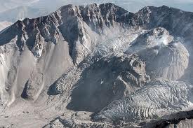
I'd like to wrap up this post by explaining a little more about the structure of the Mount St. Helens crater. When most people envision a crater, they think of something like Crater Lake. Nice and round and symmetrical. But Mount St. Helens isn't like that. The south face of the mountain looks like that. That's the side that people are talking about when they talk about climbing to the summit of Mount St. Helens.

The north side of Mount St. Helens is another story. When it erupted in 1980, almost the entire north side blasted out laterally--to the side--heading north. If you're not familiar with that terrain, here are a couple of interesting videos to bring you up to speed.

This one is only 18 seconds long. It is composed from an amazing series of photos taken by amateur photographer Gary Rosenquist, who happened to be in the right place at the right time. Here is an explanation of his sequence of photos.

This one is 7 minutes long. If you can't spare the full 7 minutes of your life, then fast forward to about 4 minutes in. There's a really good animated diagram / explanation of the lateral blast.

Sunday morning at church, someone asked me if I had to know how to arrest my fall with an ice axe before I could go into the crater. I thought he was joking, until I realized he was thinking of a Crater Lake-ish crater. Hiking into the Mount St. Helens crater was a challenging uphill hike, but we weren't going over the lip of the volcano down into the crater below. We were hiking across the pumice plain and up the debris flow to the opening in the side of the mountain.

What was the coolest thing about being in the crater? Maybe it was just the realization that I was standing inside what had once been deep inside a mountain. As we were hiking up the debris field, in an area called the Goat Rocks fan, the geologist pointed out the moment when we "stepped inside the mountain," inside the imaginary line in the air that had once been the surface contour of Mount St. Helens.

No, I didn't get to see anyone up at the summit waving down at us. I had imagined that we would, because when Mark and I climbed to the (south side) summit a year ago, we had seen scientists about the size of ants way down below us in the crater. Due to the poor visibility, I doubt that anyone actually made it to the summit last Saturday, but if they did, they weren't seeing much of the crater.

I also didn't get to see the lava dome, which would have been a cool thing, but it's not accessible except by helicopter. It's back behind the glacier, which now walls off most of the crater. (It's the only glacier in North America that is growing, not shrinking.)

But I don't care. I was there, and I made it to the crater with a hard climb, in spite of the weather. I was inside the mountain, and I loved it.

Tomorrow: Stay tuned for the descent...and the mountain goat!

Sunday, September 18, 2011

Mount St. Helens Crater: The Ascent (Part 1)

Mike, Sarah, Bridget, and Julia were correct: some more volcano adventure came my way on Friday and Saturday!

Though a lucky set of circumstances, I was given the opportunity to join a guided hike into the crater of Mount St. Helens on Saturday. WOW!! Of course I said yes and began pulling my gear together.

The hike was sponsored by the Mount St. Helens Institute. I was one of 16 participants on the hike. We were led by a USGS geologist, a biologist and the volunteer coordinator from MSHI, and two MSHI volunteers. We met at the MSHI Science Camp, near the Cascade Peaks lookout point, on Friday evening at 6:00.

Here's a photo I snapped on the way to Science Camp. Will the weather clear up? Will it rain? Only tomorrow morning would tell...
 Science Camp has two large tents, a generous and sturdy camp kitchen in between, and an outhouse-tent. As you can tell from the stove pipe, the tents are heated with wood...so cozy! The tour hosts fed us a delicious gourmet dinner inside this tent, and then we had a couple of talks by the geologist and the biologist to prepare us for what we would see on the mountain Saturday.

Most of the participants slept in the big heated tents, but I knew I would sleep better on my own. That's my sturdy red tent in the background. It's been on many backpacking hikes with me over the last twenty years or so, and best of all, it has a really good rainfly. I just didn't trust those clouds. The other tents in the foreground belong to other scientists who were based at Science Camp and out doing field work on the mountain all day every day.

Saturday morning we woke up at 5:00 am for breakfast and getting gear stowed before a 6:00 am departure for our hike. Oh, was I glad I had a good rainfly the night before...those aren't just clouds you see in the photo...those are Cascade Mountains rain clouds. I slept toasty warm and cozy, and ready to go hiking!

 Here I am at the trailhead, ready to set out. My pack included a rain jacket (I'm already wearing rain pants), extra hats, lunch, 3 liters of water, the ten outdoor essentials, and extra socks. We can see part of the mountain, but the visibility won't be good for long. This is the last photo of me for the day without my rain jacket...

 Here's our group headed west. We will be hiking between the pumice plain and Spirit Lake. Our route will be about 6 miles to get to the crater, and about 4 miles back. So far I'm feeling pretty good about this hike--good trail, level. It's in the low 40s and sprinkling, but I'm cozy inside my rain gear.

 Across the pumice plain, the trail is marked by these rock cairns. It's nice to know we won't get lost!

 Just a little further along, our guide turned left--south--toward the volcano, and off the path. For almost the whole day, we were hiking cross-country across the volcano debris. And as you can see in the photo, we were done with "level." For the next 2 1/2 miles we gained 2,000 feet on rocky, gritty, sandy terrain.

 Looking back down...agghh! Did I really just climb up that?? There's not much view in the distance because we have climbed higher and/or the clouds have come lower, and we are now in the cloud.

 Still dealing with poor visibility. Where's the view? Our hike leaders cautioned all of us to make sure we could always see the person behind us, so that no one would be left behind. He compared us to a long slinky, spread out along the trail, sometimes stretched out more, sometimes clumped together. Of course one of the MSHI volunteers always hiked the "sweep" position at the end of the group, to make sure we were all accounted for.

 Still climbing toward the crater. I love the way the landscape is so dramatic (when the clouds part and you can see it--hahaha). The canyon in the center of the photo was carved out by a small creek in just 30 years, and it's a couple hundred feet deep already! The geologist explained that the water carves the landscape so quickly here because the soil is so soft and easily moved.

 Did I mention that it was raining out? This photo was taken just after a particularly wet, nasty part. We had been hiking across a long, sloping plain, with the wind blowing a steady 40 mph (temperature in the low 40s), and rain driving right into our faces. It felt like needles. It was one of those keep-your-head-down-and-keep-hiking kinds of times. It wasn't fun, but...it was! After a while we dropped down into a little side canyon where the wind let up, and I gave a whoop - I did it! I felt strong and exhilarated to have made it through that in-your-face bluster from the weather.

Speaking of a wet hiker...and speaking of dramatic landscapes...still wet, but loving this amazing place. We are almost to the crater! We cross a small stream near this spot, and in crossing, I am just about to plant my boot on a...frog??!!

There it is, small and green in the middle of all the gray ash and red-brown rocks.
He (she?) was moving slowly in the cold weather, so the biologist scooped him up to show the other hikers. How could he live in this environment? That will be a perfect place to begin tomorrow's blog post. Come back then to read about what it was actually like inside the crater of a volcano.

Wednesday, September 14, 2011

Adventure is afoot...

Oh, I am excited. SO excited. I get to have an adventure this weekend!


Any guesses???


Stay tuned for photos on Sunday or Monday!

Saturday, September 10, 2011

9-10-11

Today is a cool date. 9 - 10 - 11. I'll bet the number of weddings and scheduled C-sections is higher today than what you'd see on an average Saturday in September. Think how much easier it will be for all those husbands to remember their anniversaries!

On the other hand, that could be a little awkward because today is, also, of course, the day before.

The thing is, ten years ago today we didn't know that. It was the day before all the bad news. So we went about our business and did our normal things because there isn't that much that's special about September 10, as a date, except for maybe once every century or so. If only all those people in the towers could have known that it was the day before, they wouldn't have gone to work the next day. The airline passengers wouldn't have climbed aboard those planes. They all would have stayed home, and they'd be alive.

But life is like that. Huge things happen to us out of the blue. Things we didn't know were coming, things we never would have predicted the day before. Terrorist attacks, tsunamis, car wrecks, betrayals. You just never know.

Today I got to thinking about my 16, 17, 18-year-old students, and what to do with them to commemorate September 11. For the first few years after 9-11, I gave my students time to write about their memories, to reflect on whatever meaning those memories held, during class time on September 11. But the last couple of years, the kids have just looked at me. They're a little jaded. They've had this writing assignment every year, for gosh sakes, and they were just little kids when it happened. They really don't remember or know that anything different is about the world today than it was the day before. Whatever fears or griefs they may have carried within them from that ugly act of terrorism, they've kind of said it all.

In another three years or so, around 2014, my juniors and seniors won't have any memories of September 11, 2001. Of course they will of heard about it, and of course it's important to teach and remember, but it won't be a personal thing. Even now, the kids in my classroom were just in kindergarten or first grade, or maybe second grade.

There is something in all this that carries such poignancy. So many thousands of lives were directly affected by the terrorist attacks. Millions more of us have had our lives profoundly change since then. And yet there are millions of young people--billions of them if you take in the global populations (and it won't be long, believe me, before they are the movers and shakers in the world, and I'm slowing down somewhere in retirement)--for whom that day, that experience, is nothing but a sad story they've heard too many times.

I know we will remember the attacks tomorrow, and of course we should. But I am certain that celebrations around joyful family events are also going on, and I'm glad we've reached the point where we can schedule a wedding the day before 9-11 and it's not weird.

For me, I think the takeaway lesson of this curious juxtaposition of dates is simply to live each day the best I can. Because every day, in someone's life, turns out to be "the day before" they weren't expecting. I'm not trying to be gruesome here, or melodramatic. It's not the kind of thing I like to think about, necessarily, but it's inescapable and true. My heart goes out to all the fine people who still grieve losses from September 11, 2001. And my hat is off to all the celebrations linked to this very cool date, September 10, 2011.

Tuesday, September 6, 2011

How to Wrap up a Summer

1. Go out to the garden and pick 5+ pounds of green beans first thing in the morning, while they're still damp from being watered the night before.

Can about half of them into pickled green beans. Here's a great recipe. YUM!! Then blanch the rest of them before tucking them into tidy packets for the freezer.

 2. Get mean with the zucchini. Show them who's boss. Even nasty dudes like this 21" bad boy.
Bust out some new zucchini recipes. Try out Summer Squash Casserole and Zucchini Pizza Casserole. You will be very popular with the eaters at your house. Oh, and be sure your daughter-in-law makes a truly yummy batch of Zucchini Bread. (Thank you, Holly!)

3. Do something girly. Rummage around in the basement and find the extra tulle from decorating your daughter's wedding a couple of years ago. Use it to make a darling tutu to send to a faraway granddaughter for her birthday. It's so easy. And so fluffy. Check out this very easy tutu tutorial.

And then...if you're a school teacher...as I am...say goodbye to Summer!

Saturday, September 3, 2011

Putting "Labor" into Labor Day Weekend

Today I spent the day at one of my very favorite places in the whole world...the Pacific Crest Trail! I talked Mark into signing up with me on a trail maintenance crew on a section of the PCT near Herman Creek, in the Columbia River Gorge. We enjoyed perfect weather (88 degrees, but we were in the shade most of the time) and met some great people on our 7-person crew.

 Everyone wears hard hats on a trail maintenance crew. I wore mine proudly today...I wasn't just out there hiking, I was working!

The Herman Creek area is so beautiful. We couldn't have asked for a lovelier place to spend the day. The section of trail in this photo did not need any maintenance, but it gives an idea of the scenery.

Here is our destination: a nasty, ankle-turning bit of talus or scree. It was difficult to walk across this section, and I watched my step carefully, remembering my nasty fall a few weeks ago. It was daunting to think that we would be able to repair this rocky section of trail in just one work session.

Who would have guessed that the primary tool used to repair trail like this is...a bucket! What that trail section needed was more rocks, and we were the "horsepower" to bring the rocks to the trail. Specifically, smaller rocks, as in gravel. Here's a photo of Mark demonstrating his manly bucket technique. I've often wondered where the trail gravel came from over my years of hiking. Did someone push a wheelbarrow full of gravel all the way from the trailhead?

Nope. When you need gravel on a trail, you scout it out. Here's another crew member, Steve Queen (he's the president of the local chapter of the Pacific Crest Trail Association), mining the "gravel pit." Earlier in the spring, trail maintenance had to be performed right here, because a (new) small stream had sent a bunch of gravel and rocks down on the trail. So our savvy work crew leader knew that we had a good source of gravel about 1/8 mile from our talus trail.

 Here's a shot of Mark up above the gravel pit, sending more rock down for us to shovel into the buckets.

Mark enjoys a welcome break for the crew. We hiked 2 miles to our work area. Then we carted uncounted buckets full of gravel from the "pit" to the scree section of the trail. Every round trip was 1/4 mile...every four round trips added another mile to our "hike." I logged over 24,000 steps on my pedometer today! I'm sure I'll sleep well tonight, but I think I'll be feeling it tomorrow.

Before we dumped our buckets of gravel, another crew member would be arranging the scree into as flat a surface as possible. Here Leif is leveling the scree with a pulaski.

And Jeanette is arranging the rocks by hand. How many times have I carelessly hiked over sections of trail that cross talus slopes, with never a thought to the work it takes to make this into a good section of trail?

Greg dumps yet another load of gravel. I swear he was sprinting up and down the trail with those buckets. How did he do it??
But that work really did pay off. Here's our fantastic crew leader, Bill Hawley, checking out the new tread. Bill was patient with us newbies, very knowledgable about trail repair, and tireless. He kept us all working safely without any nagging.

In the above photo, you can see where the loose rock is still on the trail in the bottom of the photo, and the rest of the trail is looking...WOW! So much better already! I snapped this photo when we were about 1/3 of the way up our section of trail.

A closeup shot of the trail improvement. Bill's left foot is on the improved trail, and his right foot is on the "before" section. Bill told me that it's a great compliment when hikers don't even realize that the maintenance has been done. It just looks like good trail. But I can tell you that I will never look at sections of trail like this in the same way again. When they are lovely to hike on, I'll know it's because someone sweated on a trail crew!

Leif checks out the new tread. Can you believe that we've almost finished repairing this whole section of trail?! When we first arrived, and Bill told us we'd be improving the trail section one bucket at a time, I thought to myself, "Yeah, right." I had no idea how quickly a crew of only 7 people could fix such a treacherous section of trail.

Mark and me on the way back to the trailhead. (Did I mention that we also had to hike two miles out after all that work, to get back to the car...) Here we are at the crossing of Herman Creek. Most of the trail back to the trailhead was downhill, which sounds great in theory, but in practice...ouch! Downhill hiking is so hard on knees and toes. I was the "slowpoke" of the crew, but everyone was patient and good-natured about my plodding pace.

Good by, Herman Creek! It was lovely to spend time with you today. I am sore and sunburned, but I am so glad I could "give back" to the amazing PCT.